Convenience store nearby שלגייה
Coronavirus disease (COVID-19) Situation
confirmed cases
4841772
deaths
12707
Israel
Convenience store nearby שלגייה
שלגייה
103, דרך חברון, ירושלים, IL ישראל
contacts phone
:
+972 77-400-8757
Latitude:
31.7540618
, Longitude:
35.2207705
larger map & directions
read more
nearest Convenience store
613 m
זול טוב
Yam haMelakh Street 9, Jerusalem
Convenience store
read more
723 m
מיני דודו אלקיים
גנרל פייר קניג 2, ירושלים
Convenience store
read more
726 m
מכולת דרעי ברטה
ראובן 31, ירושלים
Convenience store
read more
726 m
מכולת דרעי ברטה
Re'uven Street 31, Jerusalem
Convenience store
read more
890 m
מכולת חנניה
Hebron Road 144, Jerusalem
Convenience store
read more
890 m
מכולת חנניה
דרך חברון 144, ירושלים
Convenience store
read more
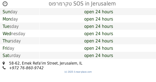
891 m
סופרמרקט SOS
Emek Refa'im Street 58-62, Jerusalem
Convenience store
read more
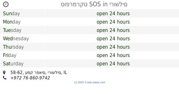
891 m
סופרמרקט SOS
עמק רפאים 58-62, ירושלים
Convenience store
read more
961 m
מינימרקט בצלאל
רבן יוחנן בן זכאי 7, ירושלים
Convenience store
read more
1.629 km
HaSuper Shelanu SOS
Halamed Hei Street 20, Jerusalem
Convenience store
read more
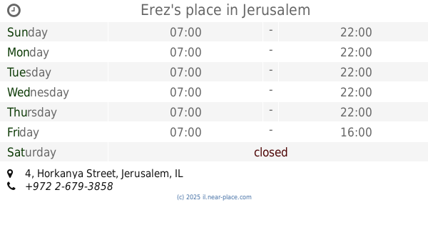
1.709 km
Erez's place
Horkanya Street 4, Jerusalem
Convenience store
read more
1.709 km
המקום של ארז
הורקניה 4, ירושלים
Convenience store
read more
1.77 km
מזנון מפגש הפלמח
HaPalmach Street 42, Jerusalem
Convenience store
read more
1.77 km
מזנון מפגש הפלמח
הפלמ"ח 42, ירושלים
Convenience store
read more
1.812 km
זול טוב
Nikkanor Street 34, Jerusalem
Convenience store
read more
1.844 km
Zol Tov
Tchernichovsky Street 45, Jerusalem
Convenience store
read more
1.844 km
זול טוב
טשרניחובסקי 45, ירושלים
Convenience store
read more
2.145 km
פיל בוקס
Azza Street 34, Jerusalem
Convenience store
read more
2.89 km
אינפוזיה
Rabbi Akiva Street 3, Jerusalem
Convenience store
read more
2.919 km
מינימרקט 24 - Minimarket 24
Hillel Street 27, Jerusalem
Convenience store
read more
3.022 km
סופר פלוס
מבוא קינמון, ירושלים
Convenience store
read more
3.304 km
מכולת חלב ודבש
בית וגן 113, ירושלים
Convenience store
read more
3.938 km
מכולת הלב הרחב
הטורים 16, ירושלים
Convenience store
read more
3.978 km
שפע ברכת השם
יואל 16, ירושלים
Convenience store
read more
5.626 km
סופר בני תורה
Ha-Rav Yitskhak Khai Tayib Street 48, Jerusalem
Convenience store
read more
📑
all categories
Accounting
Administrative area level 1
Administrative area level 2
Airport
Amusement park
Aquarium
Art gallery
Atm
Bakery
Bank
Bar
Beauty salon
Bicycle store
Book store
Bowling alley
Bus station
Cafe
Campground
Car dealer
Car rental
Car repair
Car wash
Casino
Cemetery
Church
City hall
Clothing store
Colloquial area
Convenience store
Country
Courthouse
Dentist
Department store
Doctor
Electrician
Electronics store
Embassy
Establishment
Finance
Fire station
Florist
Food
Funeral home
Furniture store
Gas station
General contractor
Grocery or supermarket
Gym
Hair care
Hardware store
Health
Hindu Temple
Home goods store
Hospital
Insurance agency
Intersection
Jewelry store
Laundry
Lawyer
Library
Light rail station
Liquor store
Local government office
Locality
Locksmith
Lodging
Meal delivery
Meal takeaway
Mosque
Movie rental
Movie theater
Moving company
Museum
Natural feature
Neighborhood
Night club
Painter
Park
Parking
Pet store
Pharmacy
Physiotherapist
Place of worship
Plumber
Point of interest
Police
Political
Post office
Premise
Real estate agency
Restaurant
Roofing contractor
Route
Rv park, camping
School
Shoe store
Shopping mall
Spa
Stadium
Storage
Store
Subpremise
Subway station
Supermarket
Synagogue
Taxi stand
Train station
Transit station
Travel agency
University
Veterinary care
Zoo
administrative area level 3
administrative area level 4
sublocality level 1
↑