Clothing store nearby Twenty Four Seven
Coronavirus disease (COVID-19) Situation
confirmed cases
4841772
deaths
12707
Israel
Clothing store nearby Twenty Four Seven
Twenty Four Seven
Weizmann Street 207, Kefar Sava Israel
contacts phone
:
+972
Latitude:
32.1723599
, Longitude:
34.927468
read more
nearest Clothing store
40 m
קיווי קידס
ויצמן 207, קניון G, Kefar Sava
Clothing store
read more
42 m
Body Shop
Weizmann Street 207, Kefar Sava
Clothing store
read more
43 m
Studio Pasha
ויצמן 207, כפר סבא
Clothing store
read more
45 m
סבון של פעם
קניון G כפר סבא, וייצמן 207, Kefar Sava
Clothing store
read more
50 m
מורנה
Weizmann Street 207, Kefar Sava
Clothing store
read more
51 m
בילבונג
ויצמן 207, כפר סבא
Clothing store
read more
57 m
Lord Kitsch
Weizmann Street 207, Kefar Sava
Clothing store
read more
60 m
ג'ינס בר
Weizmann Street 207, Kefar Sava
Clothing store
read more
84 m
יהלי
ויצמן 207, כפר סבא
Clothing store
read more
85 m
Castro
ויצמן 207, כפר סבא
Clothing store
read more
92 m
S.Wear
Weizmann Street 207, Kefar Sava
Clothing store
read more
98 m
זיפ
Weizmann Street 207, Kefar Sava
Clothing store
read more
98 m
זיפ
ויצמן 207, כפר סבא
Clothing store
read more
99 m
Hoodies
Weizmann Street 207, Kefar Sava
Clothing store
read more
108 m
Honigman
G כפר סבא, ויצמן 207, כפר סבא
Clothing store
read more
110 m
דפנה לוינסון
Weizmann Street 207, Kefar Sava
Clothing store
read more
125 m
Golbary
Weizmann Street 207, Kefar Sava
Clothing store
read more
179 m
The Children's Place
ויצמן 207, כפר סבא
Clothing store
read more
453 m
חנות מפעל Gottex
HaTa'as Street 20-22, Kefar Sava
Clothing store
read more
518 m
נעמה וענת
HaTa'as Street 24, Kefar Sava
Clothing store
read more
518 m
נעמה וענת
התע"ש 24, כפר סבא
Clothing store
read more
563 m
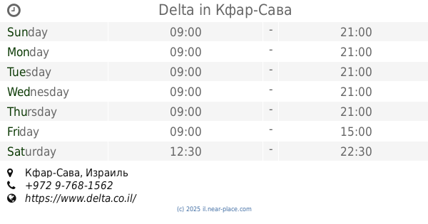
דלתא
כפר סבא
Clothing store
read more
563 m
Delta
Kefar Sava
Clothing store
read more
769 m
Carter's
עתיר ידע 4, כפר סבא
Clothing store
read more
784 m
Minene
עתיר ידע 8, כפר סבא
Clothing store
read more
📑
all categories
Accounting
Administrative area level 1
Administrative area level 2
Airport
Amusement park
Aquarium
Art gallery
Atm
Bakery
Bank
Bar
Beauty salon
Bicycle store
Book store
Bowling alley
Bus station
Cafe
Campground
Car dealer
Car rental
Car repair
Car wash
Casino
Cemetery
Church
City hall
Clothing store
Colloquial area
Convenience store
Country
Courthouse
Dentist
Department store
Doctor
Electrician
Electronics store
Embassy
Establishment
Finance
Fire station
Florist
Food
Funeral home
Furniture store
Gas station
General contractor
Grocery or supermarket
Gym
Hair care
Hardware store
Health
Hindu Temple
Home goods store
Hospital
Insurance agency
Intersection
Jewelry store
Laundry
Lawyer
Library
Light rail station
Liquor store
Local government office
Locality
Locksmith
Lodging
Meal delivery
Meal takeaway
Mosque
Movie rental
Movie theater
Moving company
Museum
Natural feature
Neighborhood
Night club
Painter
Park
Parking
Pet store
Pharmacy
Physiotherapist
Place of worship
Plumber
Point of interest
Police
Political
Post office
Premise
Real estate agency
Restaurant
Roofing contractor
Route
Rv park, camping
School
Shoe store
Shopping mall
Spa
Stadium
Storage
Store
Subpremise
Subway station
Supermarket
Synagogue
Taxi stand
Train station
Transit station
Travel agency
University
Veterinary care
Zoo
administrative area level 3
administrative area level 4
sublocality level 1
↑