Clothing store nearby רנואר
Coronavirus disease (COVID-19) Situation
confirmed cases
4841772
deaths
12707
Israel
Clothing store nearby רנואר
רנואר
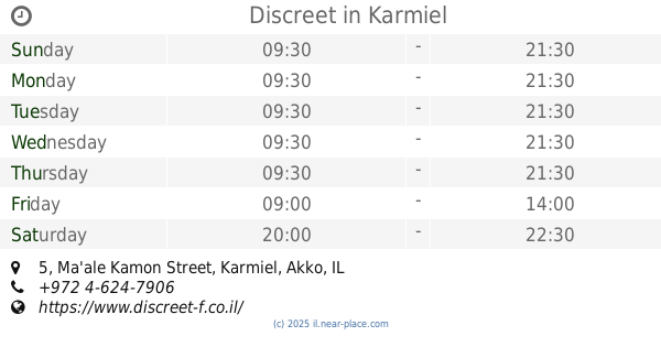
Ma'ale Kamon Street 2, Karmiel Израиль
contacts phone
:
+972
Latitude:
32.9279806
, Longitude:
35.3233948
read more
nearest Clothing store
11 m
TwentyFourSeven
Ma'ale Kamon Street 2, Karmiel
Clothing store
read more
12 m
Zip
Ma'ale Kamon Street 2, Karmiel
Clothing store
read more
27 m
TO GO
ביג כרמיאל, א.ת, מעלה כמון, כרמיאל
Clothing store
read more
42 m
תמנון
Ma'ale Kamon Street 2, Karmiel
Clothing store
read more
58 m
אינטימה
מעלה כמון 2 מרכז ביג כרמיאל, Karmiel
Clothing store
read more
91 m
FOX
Ma'ale Kamon Street 2, Karmiel
Clothing store
read more
91 m
פוקס
מעלה כמון 2, כרמיאל
Clothing store
read more
99 m
Lucci
Ma'ale Kamon Street 2, Karmiel
Clothing store
read more
120 m
s-wear (היינס)
Ma'ale Kamon Street 2, Karmiel
Clothing store
read more
122 m
Yoop
Ma'ale Kamon Street 2, Karmiel
Clothing store
read more
123 m
Castro
ביג כרמיאל, החרושת 14, כרמיאל
Clothing store
read more
153 m
יפו תל אביב
כרמיאל
Clothing store
read more
189 m
Yaffo Tel Aviv
Ma'ale Kamon Street 2, Karmiel
Clothing store
read more
213 m
H&O
מעלה כמון 2, כרמיאל
Clothing store
read more
214 m
קיווי קידס
מעלה כמון 5, קניון חוצות כרמיאל, Karmiel
Clothing store
read more
227 m
Adidas
Karmiel
Clothing store
read more
230 m
אורבניקה
Karmiel
Clothing store
read more
231 m
רמי-לי
מעלה כמון 2, כרמיאל
Clothing store
read more
243 m
Green
Ma'ale Kamon Street 9, Karmiel
Clothing store
read more
253 m
Zebra
מעלה כמון 2, כרמיאל
Clothing store
read more
257 m
Discreet
Ma'ale Kamon Street 5, Karmiel
Clothing store
read more
273 m
ג'ינספורט
מרכז מיי סנטר, מעלה כמון, כרמיאל
Clothing store
read more
299 m
הילה
מעלה כמון 9, כרמיאל
Clothing store
read more
611 m
נירלון בע''מ
הנפח 28, כרמיאל
Clothing store
read more
1.086 km
ליאור סזאר קומפלקס
Ha-Kharoshet Street 40, Karmiel
Clothing store
read more
📑
all categories
Accounting
Administrative area level 1
Administrative area level 2
Airport
Amusement park
Aquarium
Art gallery
Atm
Bakery
Bank
Bar
Beauty salon
Bicycle store
Book store
Bowling alley
Bus station
Cafe
Campground
Car dealer
Car rental
Car repair
Car wash
Casino
Cemetery
Church
City hall
Clothing store
Colloquial area
Convenience store
Country
Courthouse
Dentist
Department store
Doctor
Electrician
Electronics store
Embassy
Establishment
Finance
Fire station
Florist
Food
Funeral home
Furniture store
Gas station
General contractor
Grocery or supermarket
Gym
Hair care
Hardware store
Health
Hindu Temple
Home goods store
Hospital
Insurance agency
Intersection
Jewelry store
Laundry
Lawyer
Library
Light rail station
Liquor store
Local government office
Locality
Locksmith
Lodging
Meal delivery
Meal takeaway
Mosque
Movie rental
Movie theater
Moving company
Museum
Natural feature
Neighborhood
Night club
Painter
Park
Parking
Pet store
Pharmacy
Physiotherapist
Place of worship
Plumber
Point of interest
Police
Political
Post office
Premise
Real estate agency
Restaurant
Roofing contractor
Route
Rv park, camping
School
Shoe store
Shopping mall
Spa
Stadium
Storage
Store
Subpremise
Subway station
Supermarket
Synagogue
Taxi stand
Train station
Transit station
Travel agency
University
Veterinary care
Zoo
administrative area level 3
administrative area level 4
sublocality level 1
↑