City hall nearby עיריית אריאל
Israel
City hall nearby עיריית אריאל
עיריית אריאל
5, יהודה, אריאל, IL ישראל
contacts phone
:
+972 3-906-1600
website:
www.ariel.muni.il
Latitude:
32.104593
, Longitude:
35.172387
larger map & directions
read more
nearest City hall
Ariel Municipality
Yehuda Street 5, Ari'el
City hall
read more
8.369 km
Hawara Municipality
Nablus Street, Madaba
City hall
read more
15.148 km
بستان دير اللاتين بيرزيت
31.970349,35.199849
City hall
read more
16.571 km
Alfe Menashe Municipality
גלבוע 116, אלפי מנשה
City hall
read more
18.539 km
עיריית כפר קאסם
כפר קאסם
City hall
read more
18.539 km
החברה הכלכלית כפר קאסם
ת.ד 595, Kafr Qasim
City hall
read more
18.539 km
Kafr Qasem Municipality
Kafr Qasim
City hall
read more
19.159 km
Ras Karkar Village Council
Council Street, Ras Karkar
City hall
read more
20.603 km
מזכירות אלון מורה
City hall
read more
21.623 km
Elad Municipality
ניסים גאון 1, אלעד
City hall
read more
21.623 km
עיריית אלעד
ניסים גאון 1, אלעד
City hall
read more
22.173 km
מזכירות עינת
עינת
City hall
read more
22.189 km
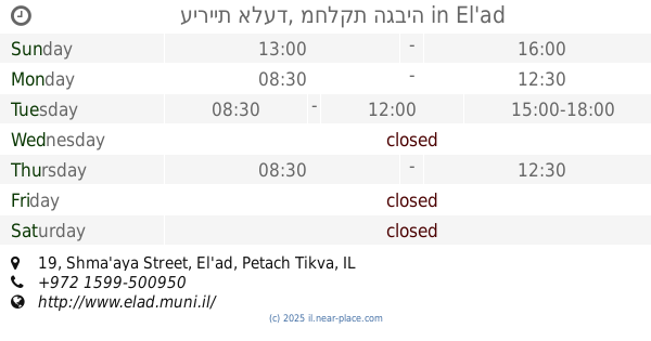
עיריית אלעד, מחלקת הגביה
Shma'aya Street 19, El'ad
City hall
read more
24.062 km
עיריית טייבה
טייבה
City hall
read more
24.062 km
Taibe Municipality
Tayibe
City hall
read more
24.396 km
בניין מועצת שוהם
HaOdem Street 63, Shoham
City hall
read more
25.21 km
מועצה אזורית חבל מודיעין
מודיעים 10, שוהם
City hall
read more
25.21 km
Hevel Modi'in Regional Council
Modi'im Street 10, Shoham
City hall
read more
25.293 km
Secretariat Shilat
Derech HaZayit 3, Shilat
City hall
read more
25.293 km
מזכירות שילת
דרך הזית 3, שילת
City hall
read more
25.695 km
Kfar Saba Municipality
Weizmann Street 135, Kefar Sava
City hall
read more
25.695 km
עיריית כפר סבא
ויצמן 135, כפר סבא
City hall
read more
26.844 km
עיריית מודיעין מכבים רעות
תלתן 1, מודיעין מכבים רעות
City hall
read more
26.844 km
Modi'in Maccabim Re'ut Municipality
Tiltan Street 1, Modi'in-Maccabim-Re'ut
City hall
read more
34.53 km
Ein AL-dyouk Al-foqa
ein AL-dyouk Al-foqa
City hall
read more
📑
all categories
Accounting
Administrative area level 1
Administrative area level 2
Airport
Amusement park
Aquarium
Art gallery
Atm
Bakery
Bank
Bar
Beauty salon
Bicycle store
Book store
Bowling alley
Bus station
Cafe
Campground
Car dealer
Car rental
Car repair
Car wash
Casino
Cemetery
Church
City hall
Clothing store
Colloquial area
Convenience store
Country
Courthouse
Dentist
Department store
Doctor
Electrician
Electronics store
Embassy
Establishment
Finance
Fire station
Florist
Food
Funeral home
Furniture store
Gas station
General contractor
Grocery or supermarket
Gym
Hair care
Hardware store
Health
Hindu Temple
Home goods store
Hospital
Insurance agency
Intersection
Jewelry store
Laundry
Lawyer
Library
Light rail station
Liquor store
Local government office
Locality
Locksmith
Lodging
Meal delivery
Meal takeaway
Mosque
Movie rental
Movie theater
Moving company
Museum
Natural feature
Neighborhood
Night club
Painter
Park
Parking
Pet store
Pharmacy
Physiotherapist
Place of worship
Plumber
Point of interest
Police
Political
Post office
Premise
Real estate agency
Restaurant
Roofing contractor
Route
Rv park, camping
School
Shoe store
Shopping mall
Spa
Stadium
Storage
Store
Subpremise
Subway station
Supermarket
Synagogue
Taxi stand
Train station
Transit station
Travel agency
University
Veterinary care
Zoo
administrative area level 3
administrative area level 4
sublocality level 1
↑