Cafe nearby Si espresso
Israel
Cafe nearby Si espresso
Si espresso
Exit to Route 6, Jat, Hadera, IL Israel
contacts phone
:
+972 4-638-3018
website:
www.sicafe.co.il
Latitude:
32.411757
, Longitude:
35.019542
larger map & directions
read more
nearest Cafe
909 m
My Cafe
Baqa al-Gharbiyye
Cafe
read more
909 m
My Cafe
באקה אל-ע'רביה
Cafe
read more
948 m
My Home, Majed
באקה אל-ע'רביה
Cafe
read more
948 m
My Home, Majed
Baqa al-Gharbiyye
Cafe
read more
2.052 km
Si Cafe Lehavot Haviva
Lehavot haviva ישראל 38835
Cafe
read more
2.052 km
Si Cafe להבות חביבה
Lehavot haviva ישראל 38835
Cafe
read more
2.112 km
נרגילת אל סולטאן
אבן ח'לדון, באקה אל-ע'רביה
Cafe
read more
2.112 km
נרגילת אל סולטאן
Ibn Haldun Street, Baqa al-Gharbiyye
Cafe
read more
2.194 km
בונז'ור באקה
Alkuds Street, Baqa al-Gharbiyye
Cafe
read more
2.533 km
בונז'ור באקה
באקה אלגרבייה
Cafe
read more
2.572 km
קונדיטוריה ומאפה אבו סולטן
Baqa al-Gharbiyye
Cafe
read more
2.664 km
בית קפה אבו ממדוח
ג'ת
Cafe
read more
2.941 km
בית קפה אלסראיא
Ahmed Abu Asva Street, Jat
Cafe
read more
3.041 km
مقهى Sunrise
Jat
Cafe
read more
3.464 km
C Espresso
Israel
Cafe
read more
3.527 km
Si espresso
Yitzhak Rabin Highway 6
Cafe
read more
4.871 km
סמא זמר sma zemer
איבטין כניסה צפונית, Zemer
Cafe
Food
Point of interest
Store
Establishment
read more
7.585 km
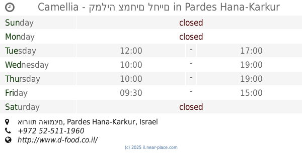
Camellia - קמליה צמחים לחיים
אורוות האומנים, Pardes Hana-Karkur
Cafe
Food
Point of interest
Establishment
read more
10.924 km
טאבון אבו ראשד
Haled Ben Al-Walid Street, Kafr Qara
Cafe
Bakery
Restaurant
Food
Point of interest
Store
Establishment
read more
10.972 km
Balkan pastry
Kafr Qara
Cafe
Food
Point of interest
Establishment
read more
11.191 km
Laymuna Cafè
شارع يافا، طولكرم
Cafe
read more
13.417 km
נרגילות אבו יוסף
7XWJ+3X, Qalansawe
Cafe
Food
Point of interest
Establishment
read more
18.315 km
Cafe Cafe
Umm al-Fahm
Cafe
read more
18.512 km
مقهى الكابتن
الخندق،, Umm al-Fahm
Cafe
Food
Point of interest
Establishment
read more
20.825 km
ברדו
הבונים 12, נתניה
Cafe
read more
📑
all categories
Accounting
Administrative area level 1
Administrative area level 2
Airport
Amusement park
Aquarium
Art gallery
Atm
Bakery
Bank
Bar
Beauty salon
Bicycle store
Book store
Bowling alley
Bus station
Cafe
Campground
Car dealer
Car rental
Car repair
Car wash
Casino
Cemetery
Church
City hall
Clothing store
Colloquial area
Convenience store
Country
Courthouse
Dentist
Department store
Doctor
Electrician
Electronics store
Embassy
Establishment
Finance
Fire station
Florist
Food
Funeral home
Furniture store
Gas station
General contractor
Grocery or supermarket
Gym
Hair care
Hardware store
Health
Hindu Temple
Home goods store
Hospital
Insurance agency
Intersection
Jewelry store
Laundry
Lawyer
Library
Light rail station
Liquor store
Local government office
Locality
Locksmith
Lodging
Meal delivery
Meal takeaway
Mosque
Movie rental
Movie theater
Moving company
Museum
Natural feature
Neighborhood
Night club
Painter
Park
Parking
Pet store
Pharmacy
Physiotherapist
Place of worship
Plumber
Point of interest
Police
Political
Post office
Premise
Real estate agency
Restaurant
Roofing contractor
Route
Rv park, camping
School
Shoe store
Shopping mall
Spa
Stadium
Storage
Store
Subpremise
Subway station
Supermarket
Synagogue
Taxi stand
Train station
Transit station
Travel agency
University
Veterinary care
Zoo
administrative area level 3
administrative area level 4
sublocality level 1
↑