Cafe nearby קפה מנדרין
Coronavirus disease (COVID-19) Situation
confirmed cases
4841772
deaths
12707
Israel
Cafe nearby קפה מנדרין
קפה מנדרין
חיפה, ישראל
contacts phone
:
+972 4-838-0803
website:
mandarin.org.il
Latitude:
32.7881506
, Longitude:
34.9681346
larger map & directions
read more
nearest Cafe
223 m
מיי קופי My Coffee
Kastra Street, Haifa
Cafe
read more
269 m
סקוואלה קפה
Flieman Street 4, Haifa
Cafe
read more
318 m
קפה מנדרין
Flieman Street 4, Haifa
Cafe
read more
329 m
Кофикс
Flieman Street 4, Haifa
Cafe
read more
329 m
Cofix
Flieman Street 4, Haifa
Cafe
read more
336 m
ארומה קניון חיפה
קניון עזריאלי חיפה, פלימן 4, Hifa
Cafe
read more
336 m
Арома
קניון עזריאלי חיפה, פלימן 4, Hifa
Cafe
read more
426 m
Greg Cafe
קניון עזריאלי חיפה, דרך משה פלימן 4, חיפה
Cafe
read more
426 m
קפה גרג
קניון עזריאלי חיפה, דרך משה פלימן 4, חיפה
Cafe
read more
837 m
רולדין מת״מ
נחום חת 5, חיפה
Cafe
read more
837 m
Roladin Matam
Nahum Het Street 5, Haifa
Cafe
Food
Point of interest
Store
Establishment
read more
850 m
Gimicafe
1 Migdal matam, Haifa
Cafe
read more
875 m
בר קפה תות
Nahum Het Street, Haifa
Cafe
read more
975 m
Cafe Market ZIM
Andrei Sakharov Street 9, Haifa
Cafe
read more
975 m
Cafe Market ZIM
אנדרי סחרוב 9, חיפה
Cafe
read more
1.158 km
Cafe Elit
תחנת הרכבת, חיפה
Cafe
read more
1.375 km
Midrahof
Haifa
Cafe
read more
1.674 km
ביגה
חורב 12, חיפה
Cafe
read more
1.902 km
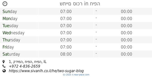
שתיים סוכר
קדימה 1, חיפה
Cafe
read more
1.902 km
Two sugar
Kadima Street 1, Haifa
Cafe
read more
1.912 km
Heine Kioscafe
Kikar Heinrich Heine 3, Haifa
Cafe
read more
2.101 km
אתגר שירותי קפה
קורצ'ק יאנוש 2, חיפה
Cafe
read more
2.11 km
קפה לי נטו בעמ
Moriya Boulevard 11, Haifa
Cafe
read more
2.143 km
קפה טורטוגה
חיפה
Cafe
read more
2.348 km
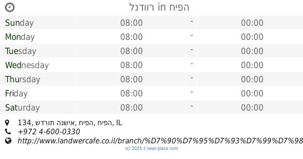
לנדוור
שדרות הנשיא 134, חיפה
Cafe
read more
📑
all categories
Accounting
Administrative area level 1
Administrative area level 2
Airport
Amusement park
Aquarium
Art gallery
Atm
Bakery
Bank
Bar
Beauty salon
Bicycle store
Book store
Bowling alley
Bus station
Cafe
Campground
Car dealer
Car rental
Car repair
Car wash
Casino
Cemetery
Church
City hall
Clothing store
Colloquial area
Convenience store
Country
Courthouse
Dentist
Department store
Doctor
Electrician
Electronics store
Embassy
Establishment
Finance
Fire station
Florist
Food
Funeral home
Furniture store
Gas station
General contractor
Grocery or supermarket
Gym
Hair care
Hardware store
Health
Hindu Temple
Home goods store
Hospital
Insurance agency
Intersection
Jewelry store
Laundry
Lawyer
Library
Light rail station
Liquor store
Local government office
Locality
Locksmith
Lodging
Meal delivery
Meal takeaway
Mosque
Movie rental
Movie theater
Moving company
Museum
Natural feature
Neighborhood
Night club
Painter
Park
Parking
Pet store
Pharmacy
Physiotherapist
Place of worship
Plumber
Point of interest
Police
Political
Post office
Premise
Real estate agency
Restaurant
Roofing contractor
Route
Rv park, camping
School
Shoe store
Shopping mall
Spa
Stadium
Storage
Store
Subpremise
Subway station
Supermarket
Synagogue
Taxi stand
Train station
Transit station
Travel agency
University
Veterinary care
Zoo
administrative area level 3
administrative area level 4
sublocality level 1
↑