Cafe nearby Horizon
Israel
Cafe nearby Horizon
Horizon
5, Ashdod Street, Tel Aviv-Yafo, IL Израиль
contacts phone
:
+972 8-865-2721
Latitude:
32.0413848
, Longitude:
34.7607914
larger map & directions
read more
nearest Cafe
397 m
קפה פאול'ס
Yerushalaim Avenue 114, Tel Aviv-Yafo
Cafe
read more
397 m
קפה פאול'ס
שדרות ירושלים 114, תל אביב יפו
Cafe
read more
751 m
לימון נענע
היינריך היינה 1-3, תל אביב יפו
Cafe
read more
751 m
לימון נענע
Heinrich Heine Street 1-3, Tel Aviv-Yafo
Cafe
read more
771 m
קפה מיכאל אנג'לו
עזה 24, תל אביב יפו
Cafe
read more
774 m
קפה מיכאלנג׳לו
בן תרדיון 2, תל אביב יפו
Cafe
read more
774 m
Michelangelo Cafe
Ben Teradion Street 2, Tel Aviv-Yafo
Cafe
read more
774 m
קפה מיכאלנג׳לו
מיכלאנג'לו 42, תל אביב יפו
Cafe
read more
830 m
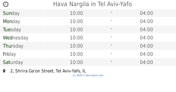
Hava Nargila
Shrira Ga'on Street 2, Tel Aviv-Yafo
Cafe
read more
886 m
Kan Zaman Hookah House
78, דרך בן צבי 72, Tel Aviv-Yafo
Cafe
read more
886 m
קאן זמאן בית נרגילה
78, דרך בן צבי 72, תל אביב יפו
Cafe
read more
890 m
Cafe Paul's
Yefet Street 142, Tel Aviv-Yafo
Cafe
read more
921 m
Double Espresso
Yehuda Hayamit Street 13, Tel Aviv-Yafo
Cafe
read more
960 m
Alma Cafe
שבטי ישראל 14, תל אביב יפו
Cafe
read more
960 m
Alma Cafe
Shivtei Israel Street 14, Tel Aviv-Yafo
Cafe
read more
1.355 km
קיוסק בלפוריה
הרצל 131, תל אביב יפו
Cafe
read more
1.374 km
cofizz
עולי ציון 10, תל אביב יפו
Cafe
read more
1.405 km
קפה בן זומא
שדרות ירושלים 22, תל אביב יפו
Cafe
read more
1.591 km
קדם קפה
Kikar Kdumim 15, Tel Aviv-Yafo
Cafe
read more
1.598 km
Caffehaz
, דויד רזיאל , 24
Cafe
read more
1.624 km
Napoleon Patisserie Cafe
מזל דגים 1, תל אביב יפו
Cafe
read more
1.688 km
Landwer
רביעיית פלורנטין, אברבאנל 72, תל אביב יפו
Cafe
read more
1.864 km
Coffee Corner
Abarbanel Street 29, Tel Aviv-Yafo
Cafe
read more
1.991 km
קפה רם
רוטשילד 35, בת ים
Cafe
read more
2.449 km
באלי קפה
Levinsky 108, Tel Aviv-Yafo
Cafe
read more
📑
all categories
Accounting
Administrative area level 1
Administrative area level 2
Airport
Amusement park
Aquarium
Art gallery
Atm
Bakery
Bank
Bar
Beauty salon
Bicycle store
Book store
Bowling alley
Bus station
Cafe
Campground
Car dealer
Car rental
Car repair
Car wash
Casino
Cemetery
Church
City hall
Clothing store
Colloquial area
Convenience store
Country
Courthouse
Dentist
Department store
Doctor
Electrician
Electronics store
Embassy
Establishment
Finance
Fire station
Florist
Food
Funeral home
Furniture store
Gas station
General contractor
Grocery or supermarket
Gym
Hair care
Hardware store
Health
Hindu Temple
Home goods store
Hospital
Insurance agency
Intersection
Jewelry store
Laundry
Lawyer
Library
Light rail station
Liquor store
Local government office
Locality
Locksmith
Lodging
Meal delivery
Meal takeaway
Mosque
Movie rental
Movie theater
Moving company
Museum
Natural feature
Neighborhood
Night club
Painter
Park
Parking
Pet store
Pharmacy
Physiotherapist
Place of worship
Plumber
Point of interest
Police
Political
Post office
Premise
Real estate agency
Restaurant
Roofing contractor
Route
Rv park, camping
School
Shoe store
Shopping mall
Spa
Stadium
Storage
Store
Subpremise
Subway station
Supermarket
Synagogue
Taxi stand
Train station
Transit station
Travel agency
University
Veterinary care
Zoo
administrative area level 3
administrative area level 4
sublocality level 1
↑