Cafe nearby Gallery corner cafe
Coronavirus disease (COVID-19) Situation
confirmed cases
4841772
deaths
12707
Israel
Cafe nearby Gallery corner cafe
Gallery corner cafe
61, Herzl Street, Haifa, Haifa, IL Israel
contacts phone
:
+972 4-866-6739
Latitude:
32.8080386
, Longitude:
35.0008469
larger map & directions
read more
nearest Cafe
52 m
Falafel Hashuk
HeHaluts Street 62, Haifa
Cafe
read more
52 m
Falafel Hashuk
החלוץ 62, חיפה
Cafe
read more
60 m
רונל'ה בית מאפה וקונדיטוריה
Herzl Street 39, Haifa
Cafe
read more
60 m
רונל'ה בית מאפה וקונדיטוריה
הרצל 39, חיפה
Cafe
read more
216 m
Laundromat Cafe
HeHaluts Street 45, Haifa
Cafe
Laundry
Food
Point of interest
Establishment
read more
386 m
קופיז
הרצל 20, חיפה
Cafe
read more
428 m
TAILS
Balfour Street 2, Haifa
Cafe
read more
451 m
Cafe Mayer
Herzl Street 23, Haifa
Cafe
read more
470 m
קפה אברמיקו
ביאליק 5, חיפה
Cafe
read more
482 m
Bialik Cafe, Haifa
Bialik Street 3, Haifa
Cafe
read more
484 m
זמן קפה
Herzl Street 18, Haifa
Cafe
Food
Point of interest
Establishment
read more
528 m
ראי
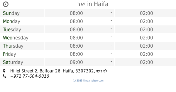
Hillel Street 2, Balfour 26, Haifa
Cafe
read more
670 m
קפה מסדה
מסדה 16, חיפה
Cafe
read more
724 m
Caffe Vero
שמואל, חיפה
Cafe
read more
727 m
Zoom Caffe
Masada Street 22, Haifa
Cafe
read more
729 m
קיווי קפה בר
הנביאים 23, חיפה
Cafe
read more
748 m
اليكا
Masada Street 24, Haifa
Cafe
read more
767 m
קופיקס
הנביאים 5, חיפה
Cafe
read more
869 m
Cafe Buono
הרצליה 12, חיפה
Cafe
read more
893 m
Cafe HaPina
Masada Street 43, Haifa
Cafe
read more
938 m
איספרה בית קפה
נתנזון 22, חיפה
Cafe
read more
938 m
איספרה בית קפה
Natanzon Street 22, Haifa
Cafe
read more
943 m
Teta's Bakery
Shabtai Levi Street 14, Haifa
Cafe
read more
1.1 km
מעבר לקפה - נועה גרינבלום
שבתאי לוי 26, חיפה
Cafe
read more
1.1 km
מעבר לקפה - נועה גרינבלום
Shabtai Levi Street 26, Haifa
Cafe
read more
📑
all categories
Accounting
Administrative area level 1
Administrative area level 2
Airport
Amusement park
Aquarium
Art gallery
Atm
Bakery
Bank
Bar
Beauty salon
Bicycle store
Book store
Bowling alley
Bus station
Cafe
Campground
Car dealer
Car rental
Car repair
Car wash
Casino
Cemetery
Church
City hall
Clothing store
Colloquial area
Convenience store
Country
Courthouse
Dentist
Department store
Doctor
Electrician
Electronics store
Embassy
Establishment
Finance
Fire station
Florist
Food
Funeral home
Furniture store
Gas station
General contractor
Grocery or supermarket
Gym
Hair care
Hardware store
Health
Hindu Temple
Home goods store
Hospital
Insurance agency
Intersection
Jewelry store
Laundry
Lawyer
Library
Light rail station
Liquor store
Local government office
Locality
Locksmith
Lodging
Meal delivery
Meal takeaway
Mosque
Movie rental
Movie theater
Moving company
Museum
Natural feature
Neighborhood
Night club
Painter
Park
Parking
Pet store
Pharmacy
Physiotherapist
Place of worship
Plumber
Point of interest
Police
Political
Post office
Premise
Real estate agency
Restaurant
Roofing contractor
Route
Rv park, camping
School
Shoe store
Shopping mall
Spa
Stadium
Storage
Store
Subpremise
Subway station
Supermarket
Synagogue
Taxi stand
Train station
Transit station
Travel agency
University
Veterinary care
Zoo
administrative area level 3
administrative area level 4
sublocality level 1
↑