Cafe nearby FassutaLike
Israel
Cafe nearby FassutaLike
FassutaLike
פסוטה, ישראל
contacts phone
:
+972 4-608-0290
Latitude:
33.0455713
, Longitude:
35.3127378
larger map & directions
read more
nearest Cafe
2.623 km
דיר קפה
Abirim
Cafe
read more
2.74 km
Dorandsivonne
41, אבירים
Cafe
read more
3.983 km
ארומה
מרכז צים, Shlomo Shrira 3, Ma'alot Tarshiha
Cafe
Food
Point of interest
Store
Establishment
read more
3.983 km
Арома
שרירא שלמה 3, מרכז צים, maalot
Cafe
read more
3.983 km
ארומה
שרירא שלמה 3, מרכז צים, maalot
Cafe
read more
4.042 km
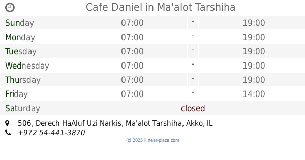
Cafe Daniel
Derech HaAluf Uzi Narkis 506, Ma'alot-Tarshiha
Cafe
read more
4.438 km
Beit Maafe maalot
ז'בוטינסקי, מעלות תרשיחא
Cafe
read more
4.438 km
Beit Maafe maalot
Jabotinsky Street, Ma'alot-Tarshiha
Cafe
read more
4.449 km
רושקה קפה גלריה
Mattat
Cafe
read more
4.465 km
קפה רושקה בגלריה והסדנא לרהיטי נפחות של יובל תלם
מצפה מתת
Cafe
read more
4.583 km
קקאו
היכל התרבות, קהילות יהדות צרפת 1, מעלות תרשיחא
Cafe
read more
4.811 km
מפגש אלוליד (כוכבה)
Hurfeish
Cafe
read more
4.811 km
מפגש אלוליד (כוכבה)
חורפיש
Cafe
read more
4.855 km
פטיסייר
כליל החורש 1, מעלות תרשיחא
Cafe
read more
4.865 km
OASIS
Israel
Cafe
read more
5.409 km
קפאין איריס וגיא
Me'ona
Cafe
read more
5.416 km
קפאין עיוני בע״מ
מעונה
Cafe
read more
5.503 km
סול קפה
מעלות תרשיחא
Cafe
read more
5.503 km
Cafe Sol
Ma'alot-Tarshiha
Cafe
read more
5.623 km
Knafe Pastry Place Jimmys
12, HaShuk Street 6, Ma'alot-Tarshiha
Cafe
read more
5.764 km
בית אלכסנדר
Ma'alot-Tarshiha
Cafe
read more
5.796 km
Grandi Cafè
Al-Mutanabi Street, Ma'alot-Tarshiha
Cafe
read more
5.796 km
Grandi Cafè
אל מותנבי, מעלות תרשיחא
Cafe
read more
5.799 km
Cafe, bakery
Ha-Knesiyot Street 2, Ma'alot-Tarshiha
Cafe
read more
5.799 km
בית קפה ,בית מאפה
הכנסיות 2, מעלות תרשיחא
Cafe
read more
📑
all categories
Accounting
Administrative area level 1
Administrative area level 2
Airport
Amusement park
Aquarium
Art gallery
Atm
Bakery
Bank
Bar
Beauty salon
Bicycle store
Book store
Bowling alley
Bus station
Cafe
Campground
Car dealer
Car rental
Car repair
Car wash
Casino
Cemetery
Church
City hall
Clothing store
Colloquial area
Convenience store
Country
Courthouse
Dentist
Department store
Doctor
Electrician
Electronics store
Embassy
Establishment
Finance
Fire station
Florist
Food
Funeral home
Furniture store
Gas station
General contractor
Grocery or supermarket
Gym
Hair care
Hardware store
Health
Hindu Temple
Home goods store
Hospital
Insurance agency
Intersection
Jewelry store
Laundry
Lawyer
Library
Light rail station
Liquor store
Local government office
Locality
Locksmith
Lodging
Meal delivery
Meal takeaway
Mosque
Movie rental
Movie theater
Moving company
Museum
Natural feature
Neighborhood
Night club
Painter
Park
Parking
Pet store
Pharmacy
Physiotherapist
Place of worship
Plumber
Point of interest
Police
Political
Post office
Premise
Real estate agency
Restaurant
Roofing contractor
Route
Rv park, camping
School
Shoe store
Shopping mall
Spa
Stadium
Storage
Store
Subpremise
Subway station
Supermarket
Synagogue
Taxi stand
Train station
Transit station
Travel agency
University
Veterinary care
Zoo
administrative area level 3
administrative area level 4
sublocality level 1
↑