Bus station nearby HaTmarim Boulevard/Roded
Israel
Bus station nearby HaTmarim Boulevard/Roded
HaTmarim Boulevard/Roded
Эйлат, Израиль
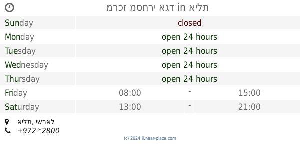
contacts phone
:
+972
Latitude:
29.562245
, Longitude:
34.9508
larger map & directions
read more
nearest Bus station
207 m
Roded/Gishron
Israel
Bus station
read more
289 m
HaTmarim Boulevard/Elot
Israel
Bus station
read more
291 m
Ye'elim/Ye'elim School
Israel
Bus station
read more
314 m
Barne'a/Barak
Israel
Bus station
read more
457 m
HaTmarim Boulevard/Ha'Almogim
Israel
Bus station
read more
470 m
HaMalcha/HaTmarim Boulevard
Israel
Bus station
read more
470 m
המלחה/שדרות התמרים
Israel
Bus station
read more
509 m
HaMalcha/Ye'elim
Israel
Bus station
read more
517 m
פארן/צין
Israel
Bus station
read more
525 m
פארן/ירושלים השלמה
Israel
Bus station
read more
546 m
Yerushalayim HaShlema/Shani
Israel
Bus station
read more
647 m
אילות/לוס אנג'לס
Israel
Bus station
read more
665 m
מרכז מסחרי אגד
אילת
Bus station
read more
704 m
מלכת שבא/ששת הימים
Israel
Bus station
read more
757 m
Hativat HaNegev/Eilat Municipality
Israel
Bus station
read more
780 m
Hativat HaNegev/Bet Hachayal
Israel
Bus station
read more
788 m
HaMutsar/Ha'Oman
Israel
Bus station
read more
845 m
HaTmarim Boulevard/Shfifon
Israel
Bus station
read more
1.004 km
נווה מדבר/משעול גירית
Israel
Bus station
read more
1.049 km
HaSatat/Big
Israel
Bus station
read more
1.054 km
מלכת שבא/האצטדיון
אילת
Bus station
read more
1.126 km
בית חולים יוספטל
Israel
Bus station
read more
1.22 km
קאמן/דרבן
Israel
Bus station
read more
1.277 km
HaSavar/HaSapan
Israel
Bus station
read more
1.279 km
ארגמן/דרך יותם
Israel
Bus station
read more
📑
all categories
Accounting
Administrative area level 1
Administrative area level 2
Airport
Amusement park
Aquarium
Art gallery
Atm
Bakery
Bank
Bar
Beauty salon
Bicycle store
Book store
Bowling alley
Bus station
Cafe
Campground
Car dealer
Car rental
Car repair
Car wash
Casino
Cemetery
Church
City hall
Clothing store
Colloquial area
Convenience store
Country
Courthouse
Dentist
Department store
Doctor
Electrician
Electronics store
Embassy
Establishment
Finance
Fire station
Florist
Food
Funeral home
Furniture store
Gas station
General contractor
Grocery or supermarket
Gym
Hair care
Hardware store
Health
Hindu Temple
Home goods store
Hospital
Insurance agency
Intersection
Jewelry store
Laundry
Lawyer
Library
Light rail station
Liquor store
Local government office
Locality
Locksmith
Lodging
Meal delivery
Meal takeaway
Mosque
Movie rental
Movie theater
Moving company
Museum
Natural feature
Neighborhood
Night club
Painter
Park
Parking
Pet store
Pharmacy
Physiotherapist
Place of worship
Plumber
Point of interest
Police
Political
Post office
Premise
Real estate agency
Restaurant
Roofing contractor
Route
Rv park, camping
School
Shoe store
Shopping mall
Spa
Stadium
Storage
Store
Subpremise
Subway station
Supermarket
Synagogue
Taxi stand
Train station
Transit station
Travel agency
University
Veterinary care
Zoo
administrative area level 3
administrative area level 4
sublocality level 1
↑