Bar nearby טינטו
Israel
Bar nearby טינטו
טינטו
107, Derech Ben Gurion, Bat Yam, IL Israel
contacts phone
:
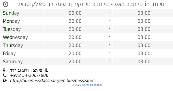
+972 54-617-0420
Latitude:
32.016153
, Longitude:
34.7386264
larger map & directions
read more
nearest Bar
טינטו
דרך בן גוריון 107, בת ים
Bar
read more
12 m
טינטו טאפאס בר
Derech Ben Gurion 105, Bat Yam
Bar
Restaurant
Food
Point of interest
Establishment
read more
20 m
Lounge Bar
Derech Ben Gurion 105, Bat Yam
Bar
read more
20 m
Lounge Bar
דרך בן גוריון 105, בת ים
Bar
read more
60 m
BG bar
Derech Ben Gurion 99, Bat Yam
Bar
read more
60 m
BG bar
דרך בן גוריון 99, בת ים
Bar
read more
220 m
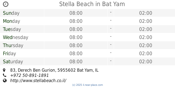
Stella Beach
Derech Ben Gurion 83, Bat Yam
Bar
Restaurant
Food
Point of interest
Establishment
read more
393 m
Cuba Libre - Русский Дэнс Бар
Derech Ben Gurion 141, Bat Yam
Bar
read more
508 m
Псия
Derech Ben Gurion 73, Bat Yam
Bar
read more
508 m
Псия
דרך בן גוריון 73, בת ים
Bar
read more
557 m
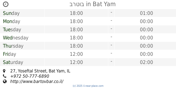
Бартов
Yoseftal Street 27, Bat Yam
Bar
read more
557 m
ברטוב
Yoseftal Street 27, Bat Yam
Bar
read more
821 m
חוף לונג ביץ
דרך בן גוריון 65, בת ים
Bar
read more
821 m
Coast Long Beach
Derech Ben Gurion 65, Bat Yam
Bar
read more
822 m
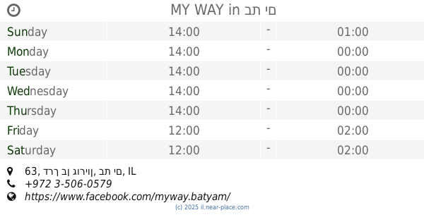
MY WAY
דרך בן גוריון 63, בת ים
Bar
read more
891 m
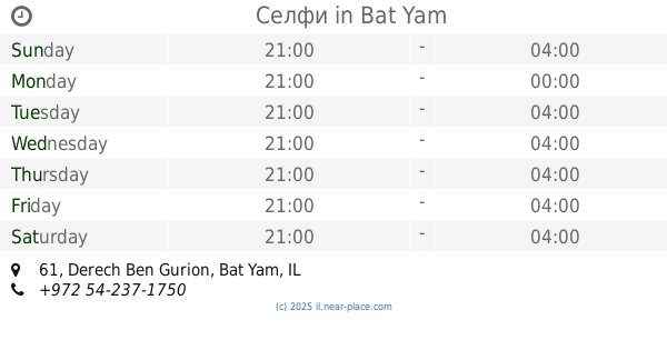
Selfie
דרך בן גוריון 61, בת ים
Bar
read more
891 m
Selfie
Derech Ben Gurion 61, Bat Yam
Bar
read more
891 m
Селфи
Derech Ben Gurion 61, Bat Yam
Bar
read more
901 m
ביזנס קלאס בר -מועדון ריקודים בבת ים - פאב בבת ים
בת ים 61, Derech Ben Gurion, Bat Yam
Bar
read more
901 m
ביזנס קלאס בר -מועדון ריקודים בבת ים - פאב בבת ים
בת ים 61, דרך בן גוריון, בת ים
Bar
read more
934 m
האורגים 2
2 5, תל אביב יפו
Bar
read more
934 m
Weavers 2
2 5, תל אביב יפו
Bar
read more
962 m
Bar Marina
Yerushalayim Street 4, Bat Yam
Bar
read more
962 m
Марина бар
Yerushalayim Street 4, Bat Yam
Bar
read more
2.008 km
מילה חוף ראשון לציון
HaTayelet 17, Rishon LeTsiyon
Bar
read more
📑
all categories
Accounting
Administrative area level 1
Administrative area level 2
Airport
Amusement park
Aquarium
Art gallery
Atm
Bakery
Bank
Bar
Beauty salon
Bicycle store
Book store
Bowling alley
Bus station
Cafe
Campground
Car dealer
Car rental
Car repair
Car wash
Casino
Cemetery
Church
City hall
Clothing store
Colloquial area
Convenience store
Country
Courthouse
Dentist
Department store
Doctor
Electrician
Electronics store
Embassy
Establishment
Finance
Fire station
Florist
Food
Funeral home
Furniture store
Gas station
General contractor
Grocery or supermarket
Gym
Hair care
Hardware store
Health
Hindu Temple
Home goods store
Hospital
Insurance agency
Intersection
Jewelry store
Laundry
Lawyer
Library
Light rail station
Liquor store
Local government office
Locality
Locksmith
Lodging
Meal delivery
Meal takeaway
Mosque
Movie rental
Movie theater
Moving company
Museum
Natural feature
Neighborhood
Night club
Painter
Park
Parking
Pet store
Pharmacy
Physiotherapist
Place of worship
Plumber
Point of interest
Police
Political
Post office
Premise
Real estate agency
Restaurant
Roofing contractor
Route
Rv park, camping
School
Shoe store
Shopping mall
Spa
Stadium
Storage
Store
Subpremise
Subway station
Supermarket
Synagogue
Taxi stand
Train station
Transit station
Travel agency
University
Veterinary care
Zoo
administrative area level 3
administrative area level 4
sublocality level 1
↑