Bar nearby Favela
Coronavirus disease (COVID-19) Situation
confirmed cases
4841772
deaths
12707
Israel
Bar nearby Favela
Favela
56, Abarbanel Street, Tel Aviv-Yafo, IL Израиль
contacts phone
:
+972 3-945-2932
website:
favela-tapas-bar.business.site
Latitude:
32.057057
, Longitude:
34.766984
larger map & directions
read more
nearest Bar
66 m
Cocktails & Dreams
HaRav Yizkhak Yedidya Frenkel 4, Tel Aviv-Yafo
Bar
read more
71 m
הגרעין
3361 22, תל אביב יפו
Bar
read more
296 m
Norma Jean
Elifelet Street 23, Tel Aviv-Yafo
Bar
read more
525 m
Диего Сан
Ha-Mashbir Street 2, Tel Aviv-Yafo
Bar
read more
542 m
קומיקס בר Comics Bar
Zevulun Street 30, Tel Aviv-Yafo
Bar
read more
559 m
המקום של בני
לוינסקי 41, תל אביב יפו
Bar
read more
578 m
מתי המקלל
Matalon Street 41, Tel Aviv-Yafo
Bar
read more
717 m
HaHalutzim Pub
Ha-Khalutzim Street 3, Tel Aviv-Yafo
Bar
read more
717 m
Rothschild 12 - רוטשילד 12
Rothschild Boulevard 12, Tel Aviv-Yafo
Bar
read more
766 m
Лима
Lilienblum Street 42, Tel Aviv-Yafo
Bar
read more
767 m
קאסה דה קוקו
פרופסור יחזקאל קויפמן, תל אביב יפו
Bar
read more
779 m
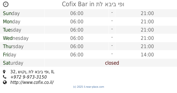
Cofix Bar
שוקן 32, תל אביב יפו
Bar
read more
827 m
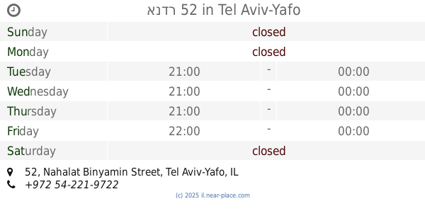
אנדר 52
Nahalat Binyamin Street 52, Tel Aviv-Yafo
Bar
read more
827 m
בר רוטשילד 22
Nahalat Binyamin Street 65, Tel Aviv-Yafo
Bar
read more
827 m
בר רוטשילד 22
נחלת בנימין 65, תל אביב יפו
Bar
read more
866 m
Спутник
Allenby Street 122, Tel Aviv-Yafo
Bar
read more
952 m
BuXa
שדרות רוטשילד 31, תל אביב יפו
Bar
read more
952 m
BuXa
Rothschild Boulevard 31, Tel Aviv-Yafo
Bar
read more
988 m
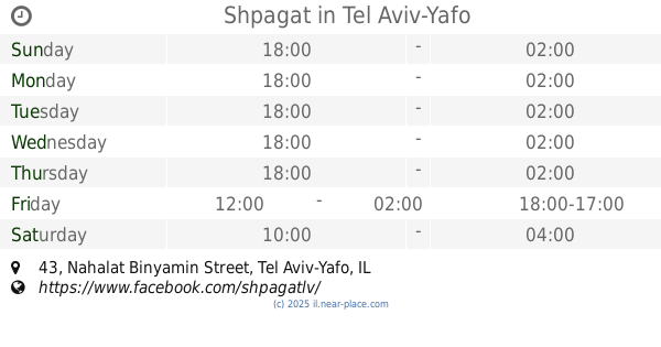
Shpagat
Nahalat Binyamin Street 43, Tel Aviv-Yafo
Bar
read more
995 m
Ariella's house-Bar
HaRakevet Street 2, Tel Aviv-Yafo
Bar
read more
1000 m
David intercontinental lobby bar
Tel Aviv-Yafo
Bar
read more
1.025 km
Bushwick
Nahalat Binyamin Street 28, Tel Aviv-Yafo
Bar
read more
1.061 km
Cuckoo's Nest
3, No'am Street, Tel Aviv-Yafo
Bar
read more
1.116 km
Abraham Hostel Tel Aviv
לבונטין 21, תל אביב יפו
Bar
read more
1.159 km
Guest Room
מקווה ישראל 26, תל אביב יפו
Bar
read more
📑
all categories
Accounting
Administrative area level 1
Administrative area level 2
Airport
Amusement park
Aquarium
Art gallery
Atm
Bakery
Bank
Bar
Beauty salon
Bicycle store
Book store
Bowling alley
Bus station
Cafe
Campground
Car dealer
Car rental
Car repair
Car wash
Casino
Cemetery
Church
City hall
Clothing store
Colloquial area
Convenience store
Country
Courthouse
Dentist
Department store
Doctor
Electrician
Electronics store
Embassy
Establishment
Finance
Fire station
Florist
Food
Funeral home
Furniture store
Gas station
General contractor
Grocery or supermarket
Gym
Hair care
Hardware store
Health
Hindu Temple
Home goods store
Hospital
Insurance agency
Intersection
Jewelry store
Laundry
Lawyer
Library
Light rail station
Liquor store
Local government office
Locality
Locksmith
Lodging
Meal delivery
Meal takeaway
Mosque
Movie rental
Movie theater
Moving company
Museum
Natural feature
Neighborhood
Night club
Painter
Park
Parking
Pet store
Pharmacy
Physiotherapist
Place of worship
Plumber
Point of interest
Police
Political
Post office
Premise
Real estate agency
Restaurant
Roofing contractor
Route
Rv park, camping
School
Shoe store
Shopping mall
Spa
Stadium
Storage
Store
Subpremise
Subway station
Supermarket
Synagogue
Taxi stand
Train station
Transit station
Travel agency
University
Veterinary care
Zoo
administrative area level 3
administrative area level 4
sublocality level 1
↑