Bar nearby Chaser Go Carmel
Coronavirus disease (COVID-19) Situation
confirmed cases
4841772
deaths
12707
Israel
Bar nearby Chaser Go Carmel
Chaser Go Carmel
116, HaNassi Boulevard, Haifa, Haifa, IL Израиль
contacts phone
:
+972 50-212-2795
website:
m.facebook.com
Latitude:
32.8062883
, Longitude:
34.9871822
larger map & directions
read more
nearest Bar
70 m
Archie's pub
שדרות הנשיא 116, חיפה
Bar
read more
70 m
Archie's pub
HaNassi Boulevard 116, Haifa
Bar
read more
91 m
Archie's pub
Unnamed Road, Haifa
Bar
read more
113 m
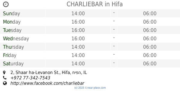
CHARLIEBAR
Shaar ha-Levanon St. 2, Hifa
Bar
read more
171 m
Sleek ~ mixing food & spirits
HaNassi Boulevard 124, Haifa
Bar
read more
177 m
Billiard Pool Pub
HaNassi Boulevard 124, Haifa
Bar
read more
177 m
מועדון סנוקר
שדרות הנשיא 124, חיפה
Bar
read more
241 m
פאב ג'ינג'י
דרך הים 8, חיפה
Bar
read more
255 m
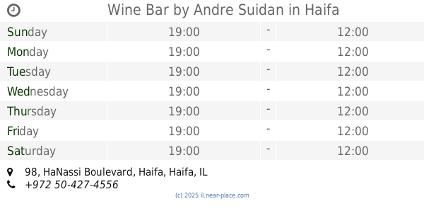
Wine Bar by Andre Suidan
שדרות הנשיא 98, חיפה
Bar
read more
255 m
Wine Bar by Andre Suidan
HaNassi Boulevard 98, Haifa
Bar
read more
271 m
Brasserie 107
Yefe Nof Street 107, Haifa
Bar
read more
300 m
Feiwel
מחניים 4, חיפה
Bar
read more
300 m
Feiwel Bar
Mahanayim Street 4, Haifa
Bar
read more
313 m
Cantina Sociale
Mahanayim Street 4, Haifa
Bar
Restaurant
Food
Point of interest
Establishment
read more
313 m
קנטינה סושיאל
Mahanayim Street 4, Haifa
Bar
read more
355 m
פטריקס
אודיטוריום כרמל, שדרות הנשיא 134, חיפה
Bar
read more
391 m
פונדק הדב
שדרות הנשיא 135, חיפה
Bar
read more
391 m
ספרייה כרמל
Sderot Wedgewood 2, Haifa
Bar
read more
391 m
Bear pub
HaNassi Boulevard 135, Haifa
Bar
read more
711 m
צ'ייסר גו מסדה
Masada Street 18, Haifa
Bar
read more
724 m
Masada Bar
Masada 21-9, Haifa
Bar
read more
766 m
Hamakolet
לוטוס 2, חיפה
Bar
read more
991 m
Frankie
Moriya Boulevard 46, Haifa
Bar
read more
991 m
פרנקי
שדרות מוריה 46, חיפה
Bar
read more
1.059 km
Pacha’s Beer Station
Nahum Dovrin Street 3, Haifa
Bar
read more
📑
all categories
Accounting
Administrative area level 1
Administrative area level 2
Airport
Amusement park
Aquarium
Art gallery
Atm
Bakery
Bank
Bar
Beauty salon
Bicycle store
Book store
Bowling alley
Bus station
Cafe
Campground
Car dealer
Car rental
Car repair
Car wash
Casino
Cemetery
Church
City hall
Clothing store
Colloquial area
Convenience store
Country
Courthouse
Dentist
Department store
Doctor
Electrician
Electronics store
Embassy
Establishment
Finance
Fire station
Florist
Food
Funeral home
Furniture store
Gas station
General contractor
Grocery or supermarket
Gym
Hair care
Hardware store
Health
Hindu Temple
Home goods store
Hospital
Insurance agency
Intersection
Jewelry store
Laundry
Lawyer
Library
Light rail station
Liquor store
Local government office
Locality
Locksmith
Lodging
Meal delivery
Meal takeaway
Mosque
Movie rental
Movie theater
Moving company
Museum
Natural feature
Neighborhood
Night club
Painter
Park
Parking
Pet store
Pharmacy
Physiotherapist
Place of worship
Plumber
Point of interest
Police
Political
Post office
Premise
Real estate agency
Restaurant
Roofing contractor
Route
Rv park, camping
School
Shoe store
Shopping mall
Spa
Stadium
Storage
Store
Subpremise
Subway station
Supermarket
Synagogue
Taxi stand
Train station
Transit station
Travel agency
University
Veterinary care
Zoo
administrative area level 3
administrative area level 4
sublocality level 1
↑