Bank nearby Leumi Bank
Israel
Bank nearby Leumi Bank
Leumi Bank
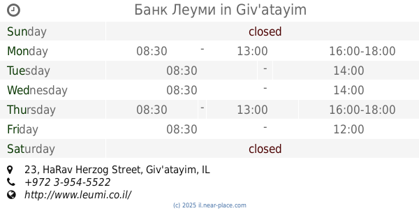
23, HaRav Herzog Street, Giv'atayim, IL Israel
contacts phone
:
+972 3-954-5522
website:
www.leumi.co.il
Latitude:
32.061512
, Longitude:
34.8164406
larger map & directions
read more
nearest Bank
24 m
בנק ישראל
HaRav Herzog Street 23, Giv'atayim
Bank
Finance
Point of interest
Establishment
read more
37 m
Банк Леуми
HaRav Herzog Street 23, Giv'atayim
Bank
read more
37 m
בנק לאומי
הרב הרצוג 23, גבעתיים
Bank
read more
193 m
Bank HaPoalim
Korazin Street 5, Giv'atayim
Bank
read more
193 m
Банк Ха-Поалим
Korazin Street 5, Giv'atayim
Bank
read more
193 m
בנק הפועלים
כורזין 5, גבעתיים
Bank
read more
226 m
מפתה דיסקונט
Tfutsot Yisra'el Street, Giv'atayim
Bank
read more
226 m
מפתה דיסקונט
תפוצות ישראל, גבעתיים
Bank
read more
543 m
דיסקונט
Derech Ben Gurion 259, Ramat Gan
Bank
read more
543 m
דיסקונט
דרך בן גוריון 259, רמת גן
Bank
read more
809 m
דיסקונט
גולני 29, רמת גן
Bank
read more
809 m
Discount Bank
Golani Street 29, Ramat Gan
Bank
read more
894 m
כספומט
Kaf Gimel Street 2, Giv'atayim
Bank
read more
894 m
כספומט
כ"ג 2, גבעתיים
Bank
read more
1.076 km
מזרחי טפחות
וייצמן 63, גבעתיים
Bank
read more
1.076 km
Банк Мизрахи
Weizman Street 63, Giv'atayim
Bank
read more
1.076 km
Mizrahi Bank
Weizman Street 63, Giv'atayim
Bank
Finance
Point of interest
Establishment
read more
1.079 km
Mizrahi Tefahot Bank
Giv'atayim
Bank
read more
1.084 km
Bank Hapoalim
Snapir Street 10, Tel Aviv-Yafo
Bank
read more
1.084 km
בנק הפועלים
סנפיר 10, תל אביב יפו
Bank
read more
1.084 km
Bank Hapoalim
סנפיר 10, תל אביב יפו
Bank
read more
1.084 km
Банк Ха-Поалим
Snapir Street 10, Tel Aviv-Yafo
Bank
read more
1.085 km
בנק
Weizman Street 65, Giv'atayim
Bank
Finance
Point of interest
Establishment
read more
1.099 km
Bank Massad
Ramat Gan
Bank
read more
1.13 km
Rocy Billing
Perets Bernstein Street, Ramat Gan
Bank
Finance
Point of interest
Establishment
read more
📑
all categories
Accounting
Administrative area level 1
Administrative area level 2
Airport
Amusement park
Aquarium
Art gallery
Atm
Bakery
Bank
Bar
Beauty salon
Bicycle store
Book store
Bowling alley
Bus station
Cafe
Campground
Car dealer
Car rental
Car repair
Car wash
Casino
Cemetery
Church
City hall
Clothing store
Colloquial area
Convenience store
Country
Courthouse
Dentist
Department store
Doctor
Electrician
Electronics store
Embassy
Establishment
Finance
Fire station
Florist
Food
Funeral home
Furniture store
Gas station
General contractor
Grocery or supermarket
Gym
Hair care
Hardware store
Health
Hindu Temple
Home goods store
Hospital
Insurance agency
Intersection
Jewelry store
Laundry
Lawyer
Library
Light rail station
Liquor store
Local government office
Locality
Locksmith
Lodging
Meal delivery
Meal takeaway
Mosque
Movie rental
Movie theater
Moving company
Museum
Natural feature
Neighborhood
Night club
Painter
Park
Parking
Pet store
Pharmacy
Physiotherapist
Place of worship
Plumber
Point of interest
Police
Political
Post office
Premise
Real estate agency
Restaurant
Roofing contractor
Route
Rv park, camping
School
Shoe store
Shopping mall
Spa
Stadium
Storage
Store
Subpremise
Subway station
Supermarket
Synagogue
Taxi stand
Train station
Transit station
Travel agency
University
Veterinary care
Zoo
administrative area level 3
administrative area level 4
sublocality level 1
↑