Bakery nearby Lehemke
Israel
Bakery nearby Lehemke
Lehemke
Kiryat Shemona, Israel
contacts phone
:
+972 4-644-1978
Latitude:
33.2208067
, Longitude:
35.5906851
larger map & directions
read more
nearest Bakery
לחמק'ה
קרית שמונה
Bakery
read more
2.211 km
פת הגליל
Qiryat Shemona
Bakery
read more
2.278 km
מאפיית כהן Ma'afiat Cohen
המכבים 12, קרית שמונה
Bakery
read more
2.278 km
מאפיית כהן Ma'afiat Cohen
Ha-Maccabim Street 12, Qiryat Shemona
Bakery
read more
3.382 km
מאפיה מרחבית קרית שמונה (1986) בעמ
א.ת. דרומי, יובל יניב, קרית שמונה
Bakery
read more
17.408 km
מאפיית הגולן
Majdal Shams
Bakery
read more
17.745 km
מאפיית אלשמס
Majdal Shams
Bakery
read more
18.909 km
שלום עלחם
חולתה
Bakery
read more
20.096 km
La pizzal'e
Merom Golan
Bakery
read more
20.096 km
לפיצה'לה
מרום גולן
Bakery
read more
21.482 km
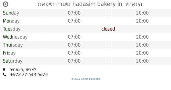
מאפיית הדסים hadasim bakery
Rehaniya
Bakery
read more
21.482 km
מאפיית הדסים hadasim bakery
ריחאניה
Bakery
read more
22.699 km
שלומית אופה עוגה
גדות
Bakery
read more
22.699 km
Salome bake a cake
גדות, Gadot
Bakery
read more
23.93 km
מאפיית פתפותים
Israel
Bakery
read more
25.796 km
מאפית גוש חלב הברכה
Jish
Bakery
read more
25.859 km
טיב חם
ישוב, ג'ש, גוש חלב
Bakery
read more
28.631 km
Rawan Majid - Sweet Boutique
טובא זנגריה
Bakery
read more
32.041 km
קונדיטוריית קפה נסים
89, Hurfeish
Bakery
read more
32.041 km
קונדיטוריית קפה נסים
89, חורפיש
Bakery
read more
47.6 km
הנחתום לחם בוטיק ופיצה גורמה
מרכז מסחרי נוף גולן בני יהודה, Bnei Yehuda
Bakery
read more
51.226 km
מאפיית לחם חמודות
דרך יחיעם 11, נהריה
Bakery
read more
51.658 km
מאפיית מנחת הארץ
שדרות הגעתון 2, נהריה
Bakery
read more
63.368 km
מאפיית מיכאל
אסף שמחוני 2-10, קרית אתא
Bakery
read more
64.553 km
Bakery On Osishkin
Mordei ha-Geta'ot Street 2, Kiryat Motzkin
Bakery
read more
📑
all categories
Accounting
Administrative area level 1
Administrative area level 2
Airport
Amusement park
Aquarium
Art gallery
Atm
Bakery
Bank
Bar
Beauty salon
Bicycle store
Book store
Bowling alley
Bus station
Cafe
Campground
Car dealer
Car rental
Car repair
Car wash
Casino
Cemetery
Church
City hall
Clothing store
Colloquial area
Convenience store
Country
Courthouse
Dentist
Department store
Doctor
Electrician
Electronics store
Embassy
Establishment
Finance
Fire station
Florist
Food
Funeral home
Furniture store
Gas station
General contractor
Grocery or supermarket
Gym
Hair care
Hardware store
Health
Hindu Temple
Home goods store
Hospital
Insurance agency
Intersection
Jewelry store
Laundry
Lawyer
Library
Light rail station
Liquor store
Local government office
Locality
Locksmith
Lodging
Meal delivery
Meal takeaway
Mosque
Movie rental
Movie theater
Moving company
Museum
Natural feature
Neighborhood
Night club
Painter
Park
Parking
Pet store
Pharmacy
Physiotherapist
Place of worship
Plumber
Point of interest
Police
Political
Post office
Premise
Real estate agency
Restaurant
Roofing contractor
Route
Rv park, camping
School
Shoe store
Shopping mall
Spa
Stadium
Storage
Store
Subpremise
Subway station
Supermarket
Synagogue
Taxi stand
Train station
Transit station
Travel agency
University
Veterinary care
Zoo
administrative area level 3
administrative area level 4
sublocality level 1
↑