Bakery nearby Ariel Bakery
Israel
Bakery nearby Ariel Bakery
Ariel Bakery
77, שדרות שאול עמור, מגדל העמק, יזרעאל, IL ישראל
contacts phone
:
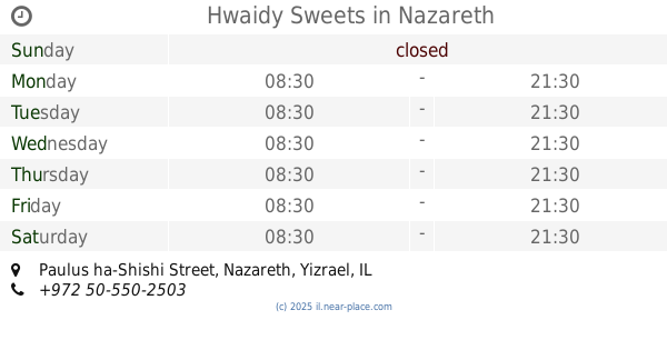
+972 4-644-0989
Latitude:
32.6889167
, Longitude:
35.2482022
larger map & directions
read more
nearest Bakery
Ariel Bakery
Sha'ul Amor Avenue 77, Migdal HaEmek
Bakery
read more
1.305 km
מאפיית אריאל
שאל, Sha'ul Amor Avenue 77, Migdal HaEmek
Bakery
read more
1.642 km
פנטזיה מתוקה
התימורים 21, מגדל העמק
Bakery
read more
1.669 km
בית הלחם
הזית 7, מגדל העמק
Bakery
read more
1.669 km
בית הלחם
HaZayit Street 7, Migdal HaEmek
Bakery
read more
1.689 km
מאפית מור השחר
23011, הזית 10, מגדל העמק
Bakery
read more
2.315 km
Angel Bakery
Nazareth
Bakery
read more
3.463 km
مخبز ابناء الحسن
Ilut
Bakery
read more
3.725 km
מאפיה ומינימרקט בני בכר בחרום
Bir al-Amir, Nazareth
Bakery
read more
3.725 km
מאפיה ומינימרקט בני בכר בחרום
ביר אל אמיר, נצרת
Bakery
read more
4.63 km
Hwaidy Sweets
Paulus ha-Shishi Street, Nazareth
Bakery
read more
4.734 km
Mahroom Bakery
Paulus ha-Shishi Street 78-90, Nazareth
Bakery
read more
4.758 km
מאפיית טאבון עין מאהל
Iksal Street 3, Nazareth
Bakery
read more
4.758 km
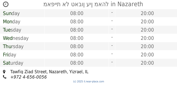
Altaboon Bakery
Tawfiq Ziad Street 4, Nazareth
Bakery
read more
4.758 km
Altaboon Bakery
תופיק זיאד 4, נצרת
Bakery
read more
4.76 km
מאפיית אל טאבון עין מאהל
Tawfiq Ziad Street, Nazareth
Bakery
read more
4.798 km
مخبز تنورين
Zarzir
Bakery
read more
5.119 km
מאפית זראזיר - مخبز الزرازير
Unnamed Road, Zarzir
Bakery
read more
5.708 km
Bakery and Grocery Abu Obeida
רח בילל 67, נצרת
Bakery
read more
5.708 km
מאפיית אבו עובידה
רח בילל 67, נצרת
Bakery
read more
5.93 km
הטבעוניות של מאמע
35, תל עדשים
Bakery
read more
5.93 km
הטבעוניות של מאמע
35, Tel Adashim
Bakery
read more
11.665 km
ביגה
Alonim Street 85, Kiryat Tiv'on
Bakery
read more
13.619 km
מאפית פת לחם
יוקנעם עילית
Bakery
read more
18.563 km
מאפיית מיכאל
אסף שמחוני 2-10, קרית אתא
Bakery
read more
📑
all categories
Accounting
Administrative area level 1
Administrative area level 2
Airport
Amusement park
Aquarium
Art gallery
Atm
Bakery
Bank
Bar
Beauty salon
Bicycle store
Book store
Bowling alley
Bus station
Cafe
Campground
Car dealer
Car rental
Car repair
Car wash
Casino
Cemetery
Church
City hall
Clothing store
Colloquial area
Convenience store
Country
Courthouse
Dentist
Department store
Doctor
Electrician
Electronics store
Embassy
Establishment
Finance
Fire station
Florist
Food
Funeral home
Furniture store
Gas station
General contractor
Grocery or supermarket
Gym
Hair care
Hardware store
Health
Hindu Temple
Home goods store
Hospital
Insurance agency
Intersection
Jewelry store
Laundry
Lawyer
Library
Light rail station
Liquor store
Local government office
Locality
Locksmith
Lodging
Meal delivery
Meal takeaway
Mosque
Movie rental
Movie theater
Moving company
Museum
Natural feature
Neighborhood
Night club
Painter
Park
Parking
Pet store
Pharmacy
Physiotherapist
Place of worship
Plumber
Point of interest
Police
Political
Post office
Premise
Real estate agency
Restaurant
Roofing contractor
Route
Rv park, camping
School
Shoe store
Shopping mall
Spa
Stadium
Storage
Store
Subpremise
Subway station
Supermarket
Synagogue
Taxi stand
Train station
Transit station
Travel agency
University
Veterinary care
Zoo
administrative area level 3
administrative area level 4
sublocality level 1
↑