Atm nearby מקום איסוף
Coronavirus disease (COVID-19) Situation
confirmed cases
4841772
deaths
12707
Israel
Atm nearby מקום איסוף
מקום איסוף
17, וייצמן, יהוד, פתח תקווה, IL ישראל
contacts phone
:
+972
Latitude:
32.0303116
, Longitude:
34.8922361
larger map & directions
read more
nearest Atm
35 m
מקום איסוף
Weizman Street 17
Atm
Finance
Point of interest
Establishment
read more
3.076 km
כספומט
משה אביב 15, אור יהודה
Atm
read more
3.076 km
כספומט
Moshe Aviv Street 15, Or Yehuda
Atm
read more
3.255 km
בנק דיסקונט
שדרות אליהו סעדון 112-120, אור יהודה
Atm
read more
3.255 km
Discount Bank
Sderot Eliyahu Sa'adon 112-120, Or Yehuda
Atm
read more
3.359 km
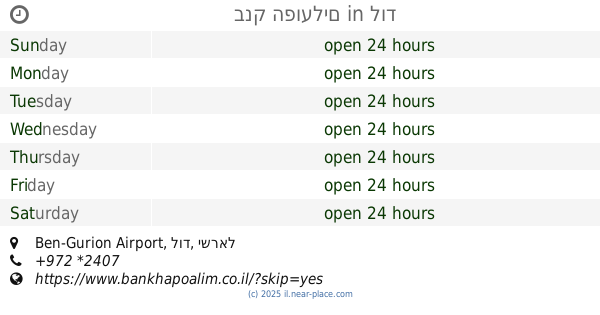
בנק הפועלים
Ben-Gurion Airport, לוד
Atm
read more
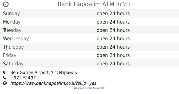
3.359 km
Bank Hapoalim ATM
Ben-Gurion Airport, לוד
Atm
read more
3.39 km
כספומט מרכז הבמה
HaCarmel Street 20, Ganei Tikva
Atm
read more
3.39 km
כספומט מרכז הבמה
הכרמל 20, גני תקווה
Atm
read more
3.903 km
כספונט
Kiryat Ono
Atm
Finance
Point of interest
Establishment
read more
3.903 km
כספונט
קרית אונו
Atm
read more
4.037 km
כספומט
Ein Ganim Street 2-4, Ganei Tikva
Atm
read more
4.091 km
כספונט שלום
Shlomo ha-Melekh Street 6, Kiryat Ono
Atm
read more
4.447 km
כספומט לאומי
Derech Levi Eshkol, Kiryat Ono
Atm
Finance
Point of interest
Establishment
read more
4.554 km
כספומט לאומי
Levi Eshkol Road, Kiryat Ono
Atm
read more
4.554 km
כספומט לאומי
דרך לוי אשכול, קרית אונו
Atm
read more
4.888 km
ATM
Yosef Sapir Street 9, Ramat Gan
Atm
read more
4.888 km
ATM
יוסף ספיר 9, רמת גן
Atm
read more
4.942 km
כספומט
Assaf Simhoni Street 26, Petah Tikva
Atm
read more
4.978 km
ATM
קרית אונו
Atm
read more
5.251 km
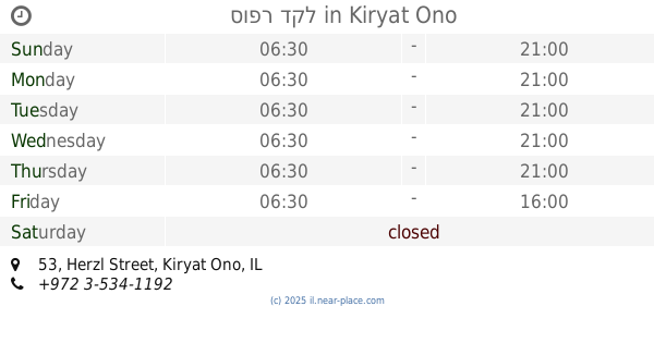
סופר דקל
Herzl Street 53, Kiryat Ono
Supermarket
Atm
Meal delivery
Grocery or supermarket
Finance
Food
Point of interest
Store
Establishment
read more
5.371 km
כספומט בנק הפועלים
HaAtsmaut Street 65, Petah Tikva
Atm
Finance
Point of interest
Establishment
read more
6.109 km
כספומט בנק דיסקונט
Oranim Street 1, Giv'at Shmuel
Atm
read more
6.119 km
כספונט
Kfar Habad
Atm
read more
6.119 km
כספונט
כפר חב"ד
Atm
read more
📑
all categories
Accounting
Administrative area level 1
Administrative area level 2
Airport
Amusement park
Aquarium
Art gallery
Atm
Bakery
Bank
Bar
Beauty salon
Bicycle store
Book store
Bowling alley
Bus station
Cafe
Campground
Car dealer
Car rental
Car repair
Car wash
Casino
Cemetery
Church
City hall
Clothing store
Colloquial area
Convenience store
Country
Courthouse
Dentist
Department store
Doctor
Electrician
Electronics store
Embassy
Establishment
Finance
Fire station
Florist
Food
Funeral home
Furniture store
Gas station
General contractor
Grocery or supermarket
Gym
Hair care
Hardware store
Health
Hindu Temple
Home goods store
Hospital
Insurance agency
Intersection
Jewelry store
Laundry
Lawyer
Library
Light rail station
Liquor store
Local government office
Locality
Locksmith
Lodging
Meal delivery
Meal takeaway
Mosque
Movie rental
Movie theater
Moving company
Museum
Natural feature
Neighborhood
Night club
Painter
Park
Parking
Pet store
Pharmacy
Physiotherapist
Place of worship
Plumber
Point of interest
Police
Political
Post office
Premise
Real estate agency
Restaurant
Roofing contractor
Route
Rv park, camping
School
Shoe store
Shopping mall
Spa
Stadium
Storage
Store
Subpremise
Subway station
Supermarket
Synagogue
Taxi stand
Train station
Transit station
Travel agency
University
Veterinary care
Zoo
administrative area level 3
administrative area level 4
sublocality level 1
↑