Atm nearby כספומט
Israel
Atm nearby כספומט
כספומט
2, Alon Tsvi Street, Netanya, HaSharon, IL Israel
contacts phone
:
+972
Latitude:
32.3266226
, Longitude:
34.8580711
larger map & directions
read more
nearest Atm
65 m
Netanya Bus Station
Pinsker Street 1, Netanya
Atm
read more
193 m
בנק פועלים
הרצל 32, נתניה
Atm
read more
283 m
כספומט
Herzl Street 23, Netanya
Atm
Finance
Point of interest
Establishment
read more
294 m
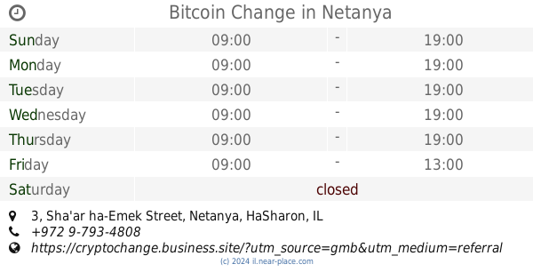
Bitcoin Change
Sha'ar ha-Emek Street 3, Netanya
Atm
Finance
Point of interest
Establishment
read more
386 m
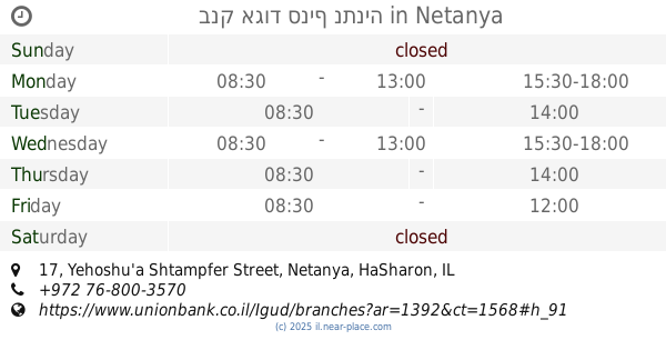
בנק אגוד סניף נתניה
Yehoshu'a Shtampfer Street 17, Netanya
Bank
Atm
Finance
Point of interest
Establishment
read more
2.012 km
כספונט
Divrei Khayim Street 16, Netanya
Atm
read more
2.012 km
ATM
Divrei Khayim Street 16, Netanya
Atm
read more
2.012 km
כספונט
דברי חיים 16, נתניה
Atm
read more
2.471 km
Discount Bank
Netanya
Atm
read more
2.471 km
כספומט בנק דיסקונט קרית השרון
נתניה
Atm
read more
4.017 km
ATM
Bitan Aharon
Atm
read more
4.313 km
ATM Bank Leumi
Netanya
Atm
read more
4.313 km
כספומט בנק לאומי
Netanya
Atm
read more
4.313 km
כספומט בנק לאומי
נתניה
Atm
read more
4.672 km
כספומט
Ha-Melakha Street 32, Netanya
Atm
read more
4.672 km
כספומט
המלאכה 32, נתניה
Atm
read more
13.236 km
כספומט
Hadera
Atm
Finance
Point of interest
Establishment
read more
13.506 km
Union Bank
Herbert Samuel Street 57, Hadera
Atm
read more
13.771 km
ATM
HaNassi Street 2, Hadera
Atm
Finance
Point of interest
Establishment
read more
14.435 km
כספומט
צה"ל 51, חדרה
Atm
read more
14.435 km
ATM
Tsahal Street 51, Hadera
Atm
Finance
Point of interest
Establishment
read more
16.641 km
בנק לאומי
צור 10, כוכב יאיר צור יגאל
Atm
read more
17.902 km
ATM Arab Bank
Main Street، قلقيلية
Atm
read more
17.919 km
ATM Bank of Palestine
الشارع الرئيسي، قلقيلية
Atm
read more
17.919 km
ATM Bank of Palestine
5XW9+8Q6، الشارع الرئيسي، قلقيلية
Atm
Finance
Point of interest
Establishment
read more
📑
all categories
Accounting
Administrative area level 1
Administrative area level 2
Airport
Amusement park
Aquarium
Art gallery
Atm
Bakery
Bank
Bar
Beauty salon
Bicycle store
Book store
Bowling alley
Bus station
Cafe
Campground
Car dealer
Car rental
Car repair
Car wash
Casino
Cemetery
Church
City hall
Clothing store
Colloquial area
Convenience store
Country
Courthouse
Dentist
Department store
Doctor
Electrician
Electronics store
Embassy
Establishment
Finance
Fire station
Florist
Food
Funeral home
Furniture store
Gas station
General contractor
Grocery or supermarket
Gym
Hair care
Hardware store
Health
Hindu Temple
Home goods store
Hospital
Insurance agency
Intersection
Jewelry store
Laundry
Lawyer
Library
Light rail station
Liquor store
Local government office
Locality
Locksmith
Lodging
Meal delivery
Meal takeaway
Mosque
Movie rental
Movie theater
Moving company
Museum
Natural feature
Neighborhood
Night club
Painter
Park
Parking
Pet store
Pharmacy
Physiotherapist
Place of worship
Plumber
Point of interest
Police
Political
Post office
Premise
Real estate agency
Restaurant
Roofing contractor
Route
Rv park, camping
School
Shoe store
Shopping mall
Spa
Stadium
Storage
Store
Subpremise
Subway station
Supermarket
Synagogue
Taxi stand
Train station
Transit station
Travel agency
University
Veterinary care
Zoo
administrative area level 3
administrative area level 4
sublocality level 1
↑