Atm nearby ATM Bank Hapoalim
Coronavirus disease (COVID-19) Situation
confirmed cases
4841772
deaths
12707
Israel
Atm nearby ATM Bank Hapoalim
ATM Bank Hapoalim
17, Ha-Rishonim Street, Metula, Tzfat, IL Israel
contacts phone
:
+972
Latitude:
33.2798283
, Longitude:
35.5786121
larger map & directions
read more
nearest Atm
כספומט בנק הפועלים
הראשונים 17, מטולה
Atm
read more
30.942 km
בנק לאומי
ג'יש
Atm
read more
30.942 km
בנק לאומי
Jish
Atm
read more
30.942 km
Банк Леуми
Jish
Atm
read more
48.934 km
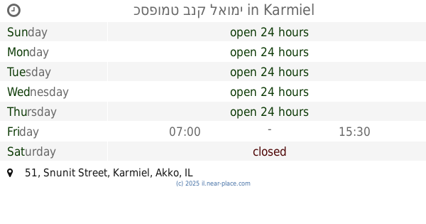
כספומט בנק לאומי
Snunit Street 51, Karmiel
Atm
Finance
Point of interest
Establishment
read more
50.413 km
בנק יורשלים
מג'ד אל-כרום
Atm
read more
50.413 km
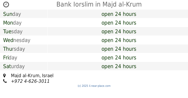
Bank Iorslim
Majd al-Krum
Atm
Finance
Point of interest
Establishment
read more
52.174 km
כספומט
רתי חספין, ראשון לציון
Atm
read more
52.395 km
כספומט מרכנתיל
עראבה
Atm
read more
54.148 km
כספומט
Sderot HaGa'aton 12, Nahariya
Atm
Finance
Point of interest
Establishment
read more
54.148 km
כספומט
שדרות הגעתון 12, נהריה
Atm
read more
54.524 km
כספומט
נהריה
Atm
read more
55.321 km
ATM
Misgav
Atm
Finance
Point of interest
Establishment
read more
55.321 km
ATM
מישגב
Atm
read more
55.86 km
בנק מרכנתיל
ג'דיידה מכר
Atm
read more
55.86 km
בנק מרכנתיל
Jadeidi-Makr
Atm
Finance
Point of interest
Establishment
read more
61.298 km
כספומטים בעכו
Ben Ami Street 16, Acre
Atm
Finance
Point of interest
Establishment
read more
61.305 km
Bank Leumi
בן עמי 4-20, עכו
Atm
read more
61.348 km
Bank Hapoalim Akko
בן עמי 4-20, עכו
Atm
read more
61.348 km
Bank Hapoalim Akko
Ben Ami Street 4-20, Acre
Atm
read more
66.72 km
kiryon
קריית ביאליק
Atm
read more
67.26 km
הבנק הבנלאומי
Keren ha-Yesod Street 68, Kiryat Bialik
Atm
read more
67.36 km
Discount Bank
Dakar Street 1, Kiryat Motzkin
Atm
Finance
Point of interest
Establishment
read more
67.364 km
Bank Leumi
Keren ha-Yesod Street 64, Kiryat Bialik
Atm
Bank
Finance
Point of interest
Establishment
read more
67.366 km
Sabine National Bank
Keren ha-Yesod Street 64, Kiryat Bialik
Atm
read more
📑
all categories
Accounting
Administrative area level 1
Administrative area level 2
Airport
Amusement park
Aquarium
Art gallery
Atm
Bakery
Bank
Bar
Beauty salon
Bicycle store
Book store
Bowling alley
Bus station
Cafe
Campground
Car dealer
Car rental
Car repair
Car wash
Casino
Cemetery
Church
City hall
Clothing store
Colloquial area
Convenience store
Country
Courthouse
Dentist
Department store
Doctor
Electrician
Electronics store
Embassy
Establishment
Finance
Fire station
Florist
Food
Funeral home
Furniture store
Gas station
General contractor
Grocery or supermarket
Gym
Hair care
Hardware store
Health
Hindu Temple
Home goods store
Hospital
Insurance agency
Intersection
Jewelry store
Laundry
Lawyer
Library
Light rail station
Liquor store
Local government office
Locality
Locksmith
Lodging
Meal delivery
Meal takeaway
Mosque
Movie rental
Movie theater
Moving company
Museum
Natural feature
Neighborhood
Night club
Painter
Park
Parking
Pet store
Pharmacy
Physiotherapist
Place of worship
Plumber
Point of interest
Police
Political
Post office
Premise
Real estate agency
Restaurant
Roofing contractor
Route
Rv park, camping
School
Shoe store
Shopping mall
Spa
Stadium
Storage
Store
Subpremise
Subway station
Supermarket
Synagogue
Taxi stand
Train station
Transit station
Travel agency
University
Veterinary care
Zoo
administrative area level 3
administrative area level 4
sublocality level 1
↑